
Some History
of the
Myers Park Neighborhood
(and surrounding areas)
Some History
of the
Myers Park Neighborhood
(and surrounding areas)
DEVELOPMENT OF NEIGHBORHOODS:
 In
June 1907, George B. Perkins, a founder of the American Sumatra Tobacco
Company, acquired control of the central portion of the Houston Plantation
by assuming a lease purchase agreement originally given by Patrick Houston's
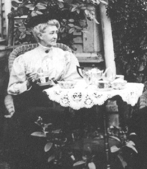
widow, Martha E. Bradford Houston (in rattan chair - photo from Florida
State Archives), a granddaughter John Branch, Florida's last
In
June 1907, George B. Perkins, a founder of the American Sumatra Tobacco
Company, acquired control of the central portion of the Houston Plantation
by assuming a lease purchase agreement originally given by Patrick Houston's
widow, Martha E. Bradford Houston (in rattan chair - photo from Florida
State Archives), a granddaughter John Branch, Florida's last  Territorial
Governor (served 1844-45 - photo from Florida State Archives).
The actual purchase in November 1907 for $10,000.00, was by the American
Sumatra Tobacco Company, with a life estate retained by Martha Bradford
Houston. In December 1910, the American Deli Tobacco Company
Territorial
Governor (served 1844-45 - photo from Florida State Archives).
The actual purchase in November 1907 for $10,000.00, was by the American
Sumatra Tobacco Company, with a life estate retained by Martha Bradford
Houston. In December 1910, the American Deli Tobacco Company 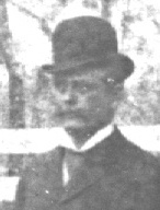 foreclosed
on the mortgage, and at a sheriff's sale (James P.S. Houston [photo
on right from Florida State Archives], a son of Patrick and Martha
Houston then being sheriff), and 1911 and 1912 Perkins acquired all of
the property that he developed into Woodland Drives subdivision from 1926
to 1930. George B. Perkins and members of his family, sold 33 acres
of land in the northwest quarter of Section 6 (T1S,R1E) to Ralph H. ("Hutch")
Gibson, for the sum of $30,000.00. That 33 acres were developed by
Gibson into Country Club Estates, now a part of the Myers Park neighborhood.
Gibson was a native of Attapulgas, Georgia, who had moved to Tallahassee
in 1924. The Tallahassee Daily Democrat, in 1926, called
Gibson "a big naval stores operator and developer." The subdivision
was surveyed and platted and lots in it went on sale in February 1926.
As an inducement to sales, Gibson offered five lots free to anyone who
would build a house costing at least $5,000.00 on them immediately.
He actually gave away four lots under this offer. That lots purchased in
the development must be built upon with a dwelling, duplex or apartment
costing at least $4,000.00 was a requirement of sale, and the property
was advertised as "restricted" which meant that lots were not to be sold
except to persons of "Caucasian" descent (of course this was a historic
requirement with no current validity). The land in the development
was taken off of the market in April 1926. At that time 64 lots had
been sold. To some extent development in Tallahassee reflected the
South Florida land boom of the 1920s, which went "bust" several years before
the "Great Depression" began in 1929. An April 8, 1926 news article
said that, "Some of the most prominent and conservative people in the City
of Tallahassee have purchased property in Country Club Estates and most
of these people will construct an attractive home on their lots in the
near future." Yet the development remained sparsely settled for some
time. In 1936 only 37 homes were listed in Country Club Estates.
This reflected a gradual shift of Tallahassee's population to various surrounding
subdivisions, and a slowdown of construction through the Depression and
the Second World War.
foreclosed
on the mortgage, and at a sheriff's sale (James P.S. Houston [photo
on right from Florida State Archives], a son of Patrick and Martha
Houston then being sheriff), and 1911 and 1912 Perkins acquired all of
the property that he developed into Woodland Drives subdivision from 1926
to 1930. George B. Perkins and members of his family, sold 33 acres
of land in the northwest quarter of Section 6 (T1S,R1E) to Ralph H. ("Hutch")
Gibson, for the sum of $30,000.00. That 33 acres were developed by
Gibson into Country Club Estates, now a part of the Myers Park neighborhood.
Gibson was a native of Attapulgas, Georgia, who had moved to Tallahassee
in 1924. The Tallahassee Daily Democrat, in 1926, called
Gibson "a big naval stores operator and developer." The subdivision
was surveyed and platted and lots in it went on sale in February 1926.
As an inducement to sales, Gibson offered five lots free to anyone who
would build a house costing at least $5,000.00 on them immediately.
He actually gave away four lots under this offer. That lots purchased in
the development must be built upon with a dwelling, duplex or apartment
costing at least $4,000.00 was a requirement of sale, and the property
was advertised as "restricted" which meant that lots were not to be sold
except to persons of "Caucasian" descent (of course this was a historic
requirement with no current validity). The land in the development
was taken off of the market in April 1926. At that time 64 lots had
been sold. To some extent development in Tallahassee reflected the
South Florida land boom of the 1920s, which went "bust" several years before
the "Great Depression" began in 1929. An April 8, 1926 news article
said that, "Some of the most prominent and conservative people in the City
of Tallahassee have purchased property in Country Club Estates and most
of these people will construct an attractive home on their lots in the
near future." Yet the development remained sparsely settled for some
time. In 1936 only 37 homes were listed in Country Club Estates.
This reflected a gradual shift of Tallahassee's population to various surrounding
subdivisions, and a slowdown of construction through the Depression and
the Second World War.
 Not
all of the Myers Park neighborhood was on the Houston plantation.
John Fray Coles (1819-1894), a cotton factor, and his wife Margaret Byrd,
arrived in Tallahassee before the Civil War. Their two sons, Flavius
Charles and John William, were involved with land in the western part of
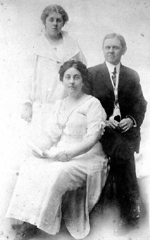
the neighborhood. Margaret Byrd Coles (LEFT - photo from Florida
State Archives), the daughter of John William Coles and Rebecca Emmaline
Flagg Coles (CENTER - photo from Florida State Archives),
married George B. Perkins (RIGHT
- photo from Florida State Archives),
who purchased the Houston plantation from the Leon Heights Improvement
Company in 1912. He and his wife owned land in the neighborhood until
1940, and he was very influential in the way the area was laid out and
developed. He initiated the first golf course in the area.
Flavius Coles owned a large farm on the east side of the present location
of Meridian Street, part of which he sold to developer Charles A. Goldsmith,
who had it platted as Golf Terrace, Unit #2. About 1884 or 1885,
Flavius and Ruth Rivers Coles built a farmhouse at the dead end of Gadsden
Street into Oakland Street. This farmhouse was occupied by their
daughter, Hattie Coles, into the mid-1980s, and is the oldest structure
standing in the neighborhood today. Around this farmhouse there were
outbuildings that housed chickens and milk cows, and vegetables were grown
there for sale in Tallahassee. Miss Hattie Coles described the area
around the farm as "a vacant lot", and said that the area known as "Houston's
Meadow" or "Houston's Hill", was popular as a place for picnics and social
gatherings.
Not
all of the Myers Park neighborhood was on the Houston plantation.
John Fray Coles (1819-1894), a cotton factor, and his wife Margaret Byrd,
arrived in Tallahassee before the Civil War. Their two sons, Flavius
Charles and John William, were involved with land in the western part of
the neighborhood. Margaret Byrd Coles (LEFT - photo from Florida
State Archives), the daughter of John William Coles and Rebecca Emmaline
Flagg Coles (CENTER - photo from Florida State Archives),
married George B. Perkins (RIGHT
- photo from Florida State Archives),
who purchased the Houston plantation from the Leon Heights Improvement
Company in 1912. He and his wife owned land in the neighborhood until
1940, and he was very influential in the way the area was laid out and
developed. He initiated the first golf course in the area.
Flavius Coles owned a large farm on the east side of the present location
of Meridian Street, part of which he sold to developer Charles A. Goldsmith,
who had it platted as Golf Terrace, Unit #2. About 1884 or 1885,
Flavius and Ruth Rivers Coles built a farmhouse at the dead end of Gadsden
Street into Oakland Street. This farmhouse was occupied by their
daughter, Hattie Coles, into the mid-1980s, and is the oldest structure
standing in the neighborhood today. Around this farmhouse there were
outbuildings that housed chickens and milk cows, and vegetables were grown
there for sale in Tallahassee. Miss Hattie Coles described the area
around the farm as "a vacant lot", and said that the area known as "Houston's
Meadow" or "Houston's Hill", was popular as a place for picnics and social
gatherings.
Charles A. Goldsmith opened Golf Terrace (Units #1 and #2) for development in 1925, and all but 8 lots in Unit #1 were reported sold by May 1926... though the city directory did not list anyone living there in 1927 and 1928. Most of the construction in that area dates from the mid-1930s through the 1940s. In spite of it's "downtown" and country club location, chickens, cows and horses were kept at houses fronting on the golf course in Golf Terrace Unit #1 during the 1930s.
 Menlo
Park subdivision, located south of Perkins Street and west of Meridian
Street and containing 35 smaller lots, was platted in 1925; however, no
houses were known to have been built in it until after World War II, at
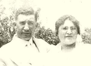
which time it was developed by Sam Mendelson and Associates. Mendelson
was an operator of furniture and department stores in Tallahassee.
(Photo of Sam Mendelson with wife Jennie, from Florida State Archives.)
Menlo
Park subdivision, located south of Perkins Street and west of Meridian
Street and containing 35 smaller lots, was platted in 1925; however, no
houses were known to have been built in it until after World War II, at
which time it was developed by Sam Mendelson and Associates. Mendelson
was an operator of furniture and department stores in Tallahassee.
(Photo of Sam Mendelson with wife Jennie, from Florida State Archives.)
The source of much of the information in this page is: Historical and Architectural Survey of the Country Club Estates Neighborhood Tallahassee, Florida, written by Sharyn M. E. Thompson and published by the Florida Secretary of State, Historic Tallahassee Preservation Board, Spring 1986. The origins of the Myers Park city park and development of the areas called the Apthorpe Survey and Kerr Survey between the Coles farmhouse and Menlo Park subdivision, west of Gadsden Street, which are a part of the Myers Park neighborhood, were not treated in Ms. Thompson's study and are still being researched by members of the neighborhood association.
Comparison of a current map with a Tallahassee Chamber of Commerce map prepared by the Engineering Department of The City of Tallahassee and dated July 1, 1940 shows that street changes have occurred in that area. Although Jennings Street was shown to exist between Meridian and Gadsden and between Adams and Bronough, it did not exist between Gadsden and Adams in 1940. Also, although Oakland and Harrison are shown to exist between Monroe and Adams in 1940, Pershing did not. Presumably at least part of this area was still wetlands at that time. Palmer Avenue was apparently the southern city limit then, as the map ends at it. The "Duck Pond" was called "Sylvan Lake" on the 1940 city map.
Looking back to the 1829 Plan of the City of Tallahassee is much more difficult. Although there have been numerous alterations over the years, some of the streets in Section "E" of that plan, the area of Tallahassee around the capitol that were a part of the previous "Original Plan of the City of Tallahassee", have retained their names and have stayed at or near their original location. That is not the case with the streets shown in the 1829 Plan in Section H (now around FAMU and the western part of the Myers Park neighborhood) and Section G (which contains the remainder of the Myers Park neighborhood). One thing is clear on that Plan, however. In 1829 there were a number of natural springs along the south side of Gaines Street and a similar feature identified as a sink and located somewhere on the western side of the Myers Park neighborhood, from which small streams flowed. These are no longer evident. Again, while the rigorous squares of streets imposed on the 1829 Plan make it appear to be rather exact, the streets were probably hypothetical, rather than real streets. The lack of persistence of street names in the area south of the Gaines Street vitiates their use as reference points, but the location of Spring Branch on the 1829 Plan seems a bit far south, even if just by reference to Gaines Street... and if that location is off, it seems likely that the locations of other natural watercourses then existing in the area south of the capitol were not precisely shown on the 1829 Plan either. These natural springs and streams no doubt then existed somewhere in the vicinity, however, and the hydrology of the area has since been extensively altered by human endeavor. To some extent, the changes may occurred just from lowering of water tables due drilling of wells in the immediate vicinity as well as the general area.
Home
History
This page was created on 5 December
1999.
Most recent revision 16 February
2000.